
March 2023 Winners:
Julian Wiltshire £50
Crispian Beattie £25
March 2023 Winners:
Julian Wiltshire £50
Crispian Beattie £25
Written by John Peddie. First published in The Deverill Valley, The Story Of An Upland Valley In South-West Wiltshire, published by the Deverill Valley History Group, December 1982.
‘And So Was England Born’
Trackway and Camp and City Lost,
Salt Marsh where now is corn –
Old Wars, old Peace, old Arts that cease,
And so was England born!
Rudyard Kipling
Alfred the Great, grandson of Egbert, King of Wessex; son of Aethelstane; architect of the beginnings of our English society and champion of the Christian faith, was a scholar, a skilled administrator and seasoned warrior despite the fact that he was of ailing health. At the age of twenty-two he was second-in-command in the campaign of Ashdown and won the confidence of the Saxon army in that year of battles, A.D.872, to such an extent that upon the sudden death of his brother he was chosen by the Witan to succeed him to the throne.
Seven years later came the crisis of his life. The Danes, led by Guthrum, having conquered Northumbria and Mercia to whom the Saxon might have looked in time of need, at last overran Wessex by an unexpected raid. Alfred was spending Christmas at his royal residence at Chippenham and his main forces were dispersed for the winter. This was normal practice but, in January A.D.878, Guthrum suddenly advanced with his host from Cirencester to Chippenham and Alfred was taken by surprise and had t0 flee. Whilst many of his subjects fled overseas the king, with a small personal warrior band and the aid of the Saxon thanes who had recently colonised Devon, established a stronghold at Athelney in the fastness of the Perret fenland, and from this base made plans and trained for a final supreme effort to save Wessex. At the same time, Guthrum occupied and fortified Chippenham from where he sent out raiding parties to ravage the surrounding countryside and re-establish contact with his Saxon opponent. These events and what happened next are graphically depicted in the Anglo-Saxon Chronicle:
In this year the host went secretly in mid-winter after Twelfth Night to Chippenham and rode over Wessex and occupied it and drove a great part of the inhabitants oversea, and of the rest the greater part they reduced to submission, except Alfred the king; and he with a small company moved under difficulties through woods and into inaccessible places in marshes . . . and after Easter, king Alfred with a small company built a fortification with the men of Athelney, and from that fortification with the men of that part of Somerset nearest to it he continued fighting against the host. Then in the 7th week after Easter he rode to Ecghryhtesstan to the east of Selwood, and came to meet him him there all the men of Somerset and Wiltshire and that part of Hampshire which was on this side of the sea and they received him warmly. And one day later he went from those camps to Iley Oak, and day later to Edington; and there he fought against the entire host and put it to flight . . .
After Alfred’s victory the transition of the West Saxon realm into the Kingdom of England was assured and fairly rapidly achieved. It was therefore a momentous event in our island history, but despite this the precise locations of the main constituents of the battle – the two meeting places prior to the battle at Egbert’s Stone and Iley Oak and the site of the battlefield itself – have always been the subject of much debate.
There are broadly two contending claimants for the battlefield site, namely the Polden Hills in West Somerset which look down upon the Parret marshes in which Alfred sought refuge from his enemy; and the downland massif upon which stands the Iron Age fort, south of Edington and Bratton villages near Westbury in Wiltshire. Strong arguments have been put forward in favour of both. There are, however, three indisputable facts which are common in each case:
First, Alfred went to ground at Athelney in the Parret fenland, where he made for himself a stronghold from which he seems to have emerged with frequency and ease to harry the Danes.
Second, Guthrum seized Chippenham in early January and established himself there in a firm winter base which he refortified and from which he despatched raiding parties into the surrounding countryside, presumably foraging and seeking information of Alfred.
Third, much of the Saxon Army was still intact; apart from the regular element which the king would have retained with him, the fyrds had scattered back to their villages awaiting his recall to arms. When this came they responded willingly and promptly to it and rallied at Egbert’s Stone, east of Selwood, where they ‘received him warmly’. Their morale, therefore, was high.
As an aid to considering the various stages of the events preceding the battle it is interesting to look at the situation as it must have appeared at the time to the opposing generals, for by doing this one can make an appreciation of the possible movements of their forces.
Alfred, in Guthrum’s eyes, must have been a shadowy figure moving with his men almost at will out out of his marshy stronghold to conduct his guerilla style raids. Any one who has experience of modern day military operations of this nature will appreciate the uncertainties in the mind of the Danish commander. Although the location of Alfred’s base was broadly known to his patrols, they were unable to reach it or pinpoint it, so that he could never really have been sure whether his enemy was in his base or out of it. His need for information about Alfred’s movements was therefore urgent and one must assume that in his efforts to deal the Saxon king a swift and mortal blow, he employed all the means open to him to glean the intelligence information he sought.
Guthrum must also have been aware of the threat posed by the fyrds, albeit scattered in Somerset, Wiltshire and Hampshire; he can be expected to have kept a watchful eye for signs of their movement. In these circumstances it could well have been unwise of Guthrum to march out of his fortified and provisioned base at Chippenham until he felt it possible to bring Alfred, with his main body, to battle on some ground of his own choosing. If in fact he did so move, he would have been foolish indeed if he had not felt conscious of the vulnerability of the firm base he had thus vacated.
For Alfred, life was not nearly so complicated. He had by now regained the initiative and clearly his prime aim must have been to re-establish his grip on Wessex by recapturing Chippenham and destroying the Danish Army. He therefore summoned the fyrds to meet him at Egbert’s Stone, a convenient and carefully chosen meeting place east of Selwood Forest. We will discuss the precise location of this rendezvous later. Suffice it to say from this long range in time, that he had two options, dependent upon whether Guthrum had moved from his Chippenham base to the Polden hills or not. If the Dane was still in occupation of his base, then Alfred’s choice was clear cut; he would march on the town to repossess himself of it and destroy the enemy. If on the other hand Guthrum had moved out of Chippenham to challenge Alfred in his fenland stronghold then the Saxon had the choice of either marching there to battle with him or of recapturing Chippenham, Guthrum’s operational but now thinly held base.
It is difficult to belive that Alfred a seasoned warrior and a shrewd general, would not have availed himself of this latter opportunity to re-establish his prestige at a blow and to isolate his enemy from his base. Similarly, it is improbable that Guthrum would have allowed him to get away with it; it is indeed more likely that he would have kept himself informed of the assembly of the Saxon Army and moved eastwards to impose himself between the Saxons and their target. Equally it is difficult to believe, in view of the facts which have been recorded , that Guthrum would have allowed himself to sit in a defensive position on the Polden Hills in such a situation, like a cat watching an empty mousehole. In either event, therefore, the weight of the argument would seem to fall in favour of the battlefield in the area of Edington near Westbury.
Lieutenant-Colonel A.H. Burne, in a paper on the subject published in the Wiltshire Archaeological Magazine, (1) expresses the view that Guthrum would inevitably have been aware of the Saxon concentration and, when its size became evident, would have called in his outlying parties to concentrate his army in a defensive position astride the route to Chippenham from Egbert’s Stone, lying to the south and to the east of Selwood Forest. The high ground offered by Bratton Castle, Edington Hill and Tinhead Hill would have almost selected itself for his purpose. Protected admirably on three sides by a long and severely steep uphill approach, Bratton Castle as a defensive position has two main deficiencies; its water supply lies over a mile away at Strad Brook, resulting in obvious complications, if not requiring the detachment of a force to protect it; and the southern flank of the Castle is exposed and vulnerable to an assault alomg the ridge trackway from Knook Castle.
It may have been that previous occupants of Bratton Castle had already appreciated this latter weakness, for an inspection of the ground and the Ordnance Survey Map reveals an old and once deeply dug ditch defending the southern flank of this ridge trackway. Lt. Colonel Burne writes about this ditch as follows:
. . . it may be that it was dug previously and perhaps made use of by the Danes. We cannot be sure. But what we can be sure about is that it is military work . . . and that it was dug for a specific purpose.
It is possible that Guthrum took the precaution of occupying this ditch position. It may be that it was his failure that he did not do so; but much would have depended upon his numerical strength to enable him to deploy manpower for this purpose. Nevertheless one may presume that whilst this phase of pre-battle activity was in progress, Guthrum had taken the precaution of pushing scouts and patrols into this area and beyond, to watch the Saxon’s movements and to provide himself with protection against surprise. He had not long to wait. Asser, Alfred’s historian, describes what happened:
At dawn on the following day he advanced his standard (from Iley Oak) to a place which is called Ethandun and fiercely warring against the whole army of the pagans with serried masses and courageously persevering for a long time, by divine favour at last gained the victory, overthrew the pagans with very great slaughter and put them to flight.
We do not here need to discuss the events of the ensuing battle further, for we are mainly interested in the location of the two meeting places used by Alfred prior to the encounter; suffice it to say the probability is that after seizing the ridge and driving in any covering troops, the Saxons would have pursued the Danes to Bratton, where fighting might have spilt over into the village of Edington itself, and thence to the gates of Chippenham. This Alfred closely besieged and after a fortnight, ‘terrified by hunger and cold and fear’, the Danes laid down their arms. Alfred had gained what has been authoritatively described as the most important victory ever won on English soil.
But what of the two meeting places used by Alfred prior to the battle? The easiest to identify is Iley Oak, for Stevenson, in his edited version of Asser’s Life of Alfred, writes that ‘this name seems to have been preserved in the case of Iley Oak or the Hundred Oak near Southleigh Woods’ until the 17th century. He adds that the Courts of the two Hundreds of Heytesbury and Warminster met at a place called Ilegh in 1439. Indeed, it is interesting to note that Iley Oak was frequently used in the mid-17th century by the Crockerton group of the non-conformist movement then spreading throughout West Wiltshire, for the purpose of holding secret religious meetings.
Today the place where the Oak would have stood is shown on the Ordnance Survey Map as Robin Hood’s Bower (GR877423) and may be identified upon the ground by an incongruous plantation of monkey puzzle trees, planted in recent years by the Longleat estate.
The selection of Iley Oak as a rendezvous for the night before the battle of Ethandun makes sound military sense; positioned in thick woodland and shielded against surprise attack by a great bend in the Wylye river. Alfred would have been enabled to approach close to the Danish position by day, unseen by the watching eyes of the enemy scouts. He would presumably have secured the crossing places over the river prior to the arrival of his main body from Egbert’s Stone, and next morning would have passed through his pickets to form up in ‘serried masses’ for the assault, perhaps during the night having already occupied the high ground offered by Battlesbury and Scratchbury features.
Where then lay Egbert’s Stone?
The Anglo-Saxon Chronicle gives two facts which provide part of the answer; for it records that Alfred ‘rode to Ecgbrythtesstan’ from Athelney and that the stone lay ‘east of Selwood’.
Selwood Forest in the time of Alfred filled the whole of the Frome valley up to the northern Avon. Extending southward to the Dorset border with Wiltshire, the forest connected with the woods and marshes of Cranborne Chase to make a formidable obstacle in the path of earlier generations of Saxons in their wars against the Romano-British. Through it ran the ancient Herepath, or Hardway as it is today shown on the Ordnance Survey Map; it crosses the south of England from the mouth of the river Axe in Devonshire to the eastern coast of Kent near Dover (2) The Hardway in earlier times must have been used as a military road by the British occupants of Cadbury Castle defending their eastern frontiers, and by Vespasian, with his 2nd Legion, who is thought to have destroyed the Castle – later to be refortified – during his invasion in A.D. 43. The Hardway, when it emerges from Selwood Forest, skirts White Sheet Castle, east of Stourton, and then runs directly to Willoughby Hedge. Alfred may be expected to have used this road, even then a historical trackway, on his march from his West Country base to Egbert’s Stone; it would have assured him speedy and safe movement, reasonably covered from interference by the movement of Danish patrols which might have been encountered further north.
Dr, Grundy, writing in the Archaeological Journal (3) in 1918, suggested that the meeting place to which Alfred was heading must have been located at or near Willoughby Hedge, since this constituted an important junction, which must have been used by the fyrds on their way to their meeting place, where trackways and ridgeways converged. The Great Ridgeway which enters Wessex at Streatley in Berkshire, the Grovely Ridgeway, which runs westward from the Hampshire border and which was an ancient trackway before the Romans took it over as part of their route to the lead mines in the Mendips, (4) and the Hardway, all meet together and intertwine on their westward route across the Wiltshire Downs, which undoubtedly brings them close to Willoughby Hedge. Burns (5) saw no reason to disagree with this line of thought; it fitted neatly and broadly into his theory of the battlefield site and he saw no reason to discuss it further.
Dr. Grundy, however, put his finger on an important factor when stressing the relevance of the trackway system to the discussion of the lost meeting place; and within that system the route taken by Alfred, after emerging from Selwood Forest, must provide a real clue if one questions at which point he would have wished to locate his rendezvous in order to turn toward the battle area with the minimum waste of time and effort.
It is necessary to pause here for a minute to consider the means by which Alfred would have called his army together. The systematic defence of the realm which he was to set in motion as a result of these wars, and known as his ‘burghal’ system, was not completed until the reign of his son, Edward. Nevertheless a chain of command existed. In order to assist him in the routine administration of his kingdom the king appointed ealdormen. Within his own area of operations the ealdorman was the king’s representative; he led the forces of his district in war and presided at its judicial assembly and it was he who sent out the call, at the behest of the king, for the assembly of the fyrds. The drill for this may be expected to have been well rehearsed and the meeting places would have been at some prominent landmark – trees, barrows or stones serving for the purpose.
A weakness of Alfred’s mobilisation system as it then existed, to be later improved by his experience, was that the assembly of his army took time. In ltanany event, dependent upon the factors of time and distance, neither the response of the men to the summons – however promptly and willingly obeyed – nor their arrival at their concentration point could be expected to be simultaneous. They would inevitably have taken a few days to assemble and Alfred may be expected to have timed his arrival accordingly.
The force when assembled is thought to have numbered about 4,000 men. Since many of these would have been encamped for about two or three days, a suitable area of sheltered well-drained land, together with an adequate supply of water for men and beasts, would have been an essential requirement. There are thus two important factors the king would have borne in mind when naming the meeting place, namely its fitness as an assembly area and the availability of good track communications from it in the direction of the enemy; and when considering its fitness he would not have overlooked the importance of concealment and security. Any claim therefore to the location of Egbert’s Stone, although inevitably based largely on conjecture due to the almost total absence of known facts, would need to be considered in the light of these requirements.
Probably the longest standing claim for the site is that made by Mr. Hoare of Stourhead who erected Alfred’s Tower in 1760 on Kingsettle Hill (GR745352). A more likely site might have been the Fort area at Six Wells Bottom. There is a local tradition that the Six Springs of Stourhead as they were formerly known and which mark the source of the river Stour, sprang from ground on an occasion when Alfred was present there and was thirsty and prayed for water. A few hundred yards eastward from this point, along the Hardway, an ancient trackway strikes off towards Cley Hill and Warminster; the Redway diverts from it to Crockerton, where it crosses the river Wylye to Iley Oak. An important consideration in favour of this site is the proximity of the village of Stourton. Colt Hoare records (6) that the Stourton family were of pre-Conquest origin and quotes that ‘William the Conqueror came into the west to receive their rendition’ there, and that the ‘Lord Abbot of Glastonbury, and the rest of the Lords, and the Grandees of the Western parts waited upon the family at Stourton’ at that ceremony. This was plainly an important Saxon location long before the Conquest and possesses many of the physical military requirements to make a good assembly area.
The site at Coombe Street (GR773312) is worthy of close consideration. A large stone, standing on the banks of the river Stour, is claimed locally to be Egbert’s Stone, placed byt him to mark the junction point of the boundaries of Dorset, Wiltshire and Somerset. The site contains many of the necessary qualities; there is a good water supply and it would have been well concealed in a well-populated and strongly Saxon part of the forest, albeit about four miles in a direct line from the Hardway and lying that much further south from Iley Oak. The location at the three county boundary is argued to be conclusive and to have an administrative significance for the country fyrds. This is not compellingly acceptable since the Anglo Saxon Chronicle records that Alfred’s army comprised ‘the men of Somerset and Wiltshire and that part of Hampshire which was on this side of the sea . . .’ The men of Dorset, who were possibly watching for Viking intervention from the south coast, were not present. Nevertheless, Coombe Street appears a very possible location.
Dr. Grundy’s choice of Willoughby Hedge (GR866336), the case for which has already been argued above and which at one time was strongly favoured, may perhaps be judged to lie too far east of Selwood and to lack a suitable water supply. Moreover, although it is undoubtedly located at the hub of a number of important trackways, it is situated in a very elevated and – viewed through 20th century eyes – exposed position. A fact which Dr. Grundy did not utilise, however, is that two Roman roads converge on this same piece of downland, one of them actually crossing the Hardway at Willoughby Hedge, before momentarily coming together at the ford at Kingston Deverill. These are the Roman ‘Lead’ road and Vespasian’s strategic road from Poole to Bath. Since the ‘Lead’ road also meets with the Ridgeways on their passage across the neighbouring downland, this gives the nearby Kingston Deverill an importance not so far noted. This importance is emphasised by the presence of an obviously ancient pathway, marked along its length by eight tumuli, which runs from the Hardway at White Sheet Castle to the village, and which crosses Court Hill on its way. A short distance due south of Court Hill lies King’s Hill.
Kingston Deverill has long had association with the Crown; prior to the Domesday Survey it was held by Edith, Queen of Edward the Confessor, a descendant of Egbert. Subsequently it became one of the grants of the Earls of Cornwall and later formed part of the estate of the Duchy of Cornwall. It is with no surprise therefore that once again we discover another stone monument with possible association with King Egbert. This was recorded in the Wiltshire Archaeological Magazine in 1877 in the following words:
In the rectory garden certain large stones were examined: they are called ‘Egbert’s Stone’ or ‘King’s Stone’ and are spoken of by the Saxon Chroniclers; they were brought by a farmer from King’s Court Hill, where Egbert is traditionally said to have held court, and for some time did duty as stepping stones to a barn; subsequently they were condemned to be broken up as material for mending roads, but their substance was so hard as to defy the efforts of their would be destroyers . . . (7)
These stones today, standing at an angle and leaning against each other, are to be found in the field adjoining the church at Kingston Deverill. Originally there were three of them, two standing perfectly upright and the third placed across the top as a cap-stone. (8) They are without doubt Sarsen stones, a recognised medium which provided early man with the material for his monuments and the greatest density of which is to be found on the Marlborough Downs. In general terms, however, they may be discovered throughout the whole of southern England. They have been used for a multitude of purposes – the Romans, for example, employed them frequently as milestones – and isolated stones lying upon the downs have almost certainly been brought there for a specific reason. The stone on the banks of the Stour at Coombe Street, as a further example, would seem to have been brought there in the distant past as a marker to indicate the point where the three county boundaries meet together.
In 1901 Mrs. Cunnington wrote about the Kingston Deverill stones in a note to the Wiltshire Archaeological Magazine and wondered about their origins. (9) E.A. Rawlence, the militaty historian who had already written in the Antiquaries Journal a carefully reasoned article placing the site of the Battle of Ethandun in the area of Bratton, at once took up the question which Mrs. Cunnington had posed, but not answered, and wrote: (10)
. . . . is it not possible, nay probable, that these stones are the ‘Petra Ecbricti’ where King Alfred assembled his army before he marched to attack the Danes at Ethandune . . . The knolls (i.e. King’s Hill and Court Hill) were probably associated with some royal event and possibly one or other was the site of Petra Ecbricti and therefore marks the site of King Alfred’s well known trysting place, which from a military point of view, was extraordinarily well chosen . . .
The fact that Rawlence, who had devoted considerable study to this phase of Alfred’s operations against the Danes, wrote on these terms means that the questions must then be asked: did the rallying call which the king sent out to his countrymen, summoning them to battle at Ethandun, bring them to a meeting place on Court Hill? and is this the place where Egbert’s Stone then stood? and are the stones which stand today in the field adjoining the church at Kingston Deverill, the remains of a monument of great historical importance, the whereabouts of which has been sought for so long? There is a strong oral tradition at Kingston which adds strength to the argument: this is that Alfred the Great, before the battle, climbed King’s Hill with his captains to look at the Danish position. Can it be coincidence that standing today by the barn at the top of the hill, one not only gets a clear view straight down the valley of the Deverill to the Battlesbury and Scratchbury features beyond, but one can also see Southleigh Woods which conceal Iley Oak, Alfred’s eve of battle resting place?
And so was England born?
Notes
(1) Wiltshire Archaeological Magazine [W.A.M.], vol.53, p.400. See also Lt. Col. A.H. Burne, More Battlefields of England, London, 1952.
(2) H.W. Timperley, & E. Brill, Ancient Trackways of Wessex, Phoenix House, 1965, ch.4.
(3)W.A.M. vol.75.
(4) Timperley & Brill, op. cit., ch.23.
(5) D. Whitelock, The Beginnings of English Society, Penguin, 1952.
(6) Sir Richard Colt Hoare, The History of Wiltshire: (a) Hundred of Mere, 1822; (b) Hundred of Heytesbury, 1824.
(7) W.A.M., vol.17 – Excursion on 23rd August 1877.
(8) This cap stone is now missing. It is said to have been removed during the Second World War and used as a stepping stone at the Rectory, then an Officers’ Mess. Both field and Rectory now belong to Mr. Robert Brown.
(9) W.A.M., vol.44, p.261.
(10) W.A.M. vol.45, pp.86/7.
Additional Bibliography
W. Stevenson (ed.), Asser’s Life of Alfred, Clarendon Press, 1904.
A. Napier, Early Wars of Wessex, Blandford Press, 1913.
D.A. Hinton, Alfred’s Kingdom, Dent, 1977.
H. Ross: Alfred and the Battle of Edington, lecture dated 21st March 1978.
By Richard Stratton:
But they will maintain the fabric of the world;
And in the handywork of their craft is their prayer.
Ecclesiasticus 38. v. 34Two thousand years ago the settled population of this country was found on the chalk hills of Southern England – the Cotswolds, west Dorset, and eastward to Kent and the Chiltern Hills. Just as Salisbury has long been a market city through being at the confluence of five rivers, so our ancestors sited their capital where the Thames drew them to the sea. At London’s back door they colonised the light lands of Hertfordshire, Norfolk and Suffolk. It was only on easy working soil that the primitive scratch plough pulled by two oxen could make any penetration. The high chalk has always been a forester’s nightmare but, in Iron Age times, it required minimal clearance. The heavy axe and mouldboard plough which was to tackle the oak, ash and beech forests on the clay of England arrived with the Belgae only shortly before the Christian era.
Chalkland may be thin of soil but it is well drained, the water being held like a sponge by the chalk beneath. Farmers have long known that corn yields excel in a wet season, and nowadays it is accepted that the amalgam of moderate summer temperatures, long days, and ample rainfall, provide almost ideal conditions for top yields of cereals. Down the centuries, from the Saxons struggling to develop the mouldboard plough to Jethro Tull’s corn drill and on to the machinery that we see today, chalk farmers have at least been working on a rewarding medium.
When considering the saga of farming in the Deverills over the last two centuries, it is suggested that we survey the scene at 50 year intervals, i.e. 1780, 1830, 1880, 1930 and 1980. Each date has in fact marked a turning point in the story.
First we must learn the changeful moods of heavens,
And all the winds, and of each several field
The natural character, what this consents,
What that declines to bear. Here cereals thrive,
There grapes more gladly ripen, here again
Green saplings flourish and unbidden grass.
Thus on each region Nature long ago
Her stern necessities and changeless laws Imposed . . .
– Virgil.
In the 18th Century the difficult clays of North and West Wiltshire were given, of necessity, to permanent grass and this was cashed in the form of milk and cheese. Farmers and herdsmen were scattered near cattle steadings and thus escaped the full rigours of the manorial system. Fifty year later they were to provide the forceful men who developed dairies and the modern corn techniques on the neighbouring uplands.
By 1780, away in Norfolk, Thomas Coke was just beginning to demonstrate his four-course rotation of turnips barley or oats, clover and grass ley, and finally wheat. The basis of farming in the Deverills, as in much of the country was still the Open Field system, in which tractable land near the village was divided into innumerable small strips of less than one acre each, these then being allocated by the Lord of the Manor (in Kingston, Lord Bath) to leaseholders so that each had a plot in each field. When the system was first introduced from the Mediterranean seaboard the rotation would have been corn and fallow alternately to conserve moisture. In England it was soon extended to two years cereals, followed by one year fallow.
The villages grew up near the river for the sake of a water supply. Even in the author’s childhood the river contained vastly more water than now, for the pumps at Mere had not lowered our water table and there were good hatches everywhere. There would in 1780 have been ample water to power the grist mills at Monkton and Hill Deverills. Especially in spring, flooding the water meadows for early grass presented no problem. Away from the water meadows and the Open Fields were the unenclosed Downs capped with gorse. Wood for fuel was a continuing concern and many of the woods that we see today would have then been hazel coppice, a certain proportion being cut each year. We have recently learnt that no other method of forestry yields more timber per acre. The bound faggots were used for housewarming and bake ovens, and the better wood had innumerable uses for building, thatching spars, hurdle making and garden use.
The prosperity of our villages was linked to the Wiltshire Horn ewes which were organised communally and ranged the Downs every day in charge of shepherds. The vital thing was that by night they were penned in a moveable fold of hurdles on the cultivated strips, thus manuring the soil and allowing wheat to be grown. This process however took a great deal from the Downs and put nothing back, so that after 150 years of it they had been drained of their fertility. The drawback to the system was the lack of sheep food in winter, which is notoriously long and severe hereabouts. Everything, except actual breeding ewes and ewe lambs had to be sold or salted down in the autumn. Hay from the meadows was reserved until after Christmas. Salvation was provided by the water meadows which could be made to produce a flush of grass for the ewes and their lambs in March/April; when at last the Downs grew in May the meadows were shut up for hay. Sometimes vetches were grown on the fallow strips for midsummer folding.
In modern times Wiltshire is easily accessible, but in 1780 it consisted of a number of remote and largely self-contained communities. A surveyor of the time records:
“Wiltshire, as being partly a corn and partly a grass county, is capable of producing most of the articles of human sustenance, and, being in general a well cultivated district, its produce is considerably more than its consumption. The principal products are corn, chiefly wheat and barley, cheese and butter; fat calves; fat cattle and sheep and fat pigs. The manufacturing towns within the county and in the eastern parts of Somerset and the cities of Bath and Bristol furnish a constant regular demand for these products and London took no inconsiderable part of them.’ (1) As far as the Deverill Valley was concerned, much of its business would have been through the market at Warminster and the various local sheep fairs, through which huge numbers of store animals were sold for fattening in the Eastern counties.
There is no doubt that the local villages of the 1780’s were busy, self-sufficient communities. Those men not hired to work on the land found employment in service occupations as road-makers, carriers, drowners, thatchers, builders, bakers, smiths or millers, the few unable to work being given some support on parish relief. The women too were all busy with their domestic duties, and probably also organised some basic education for their children under the supervision of the parson. Dwellings were primitive and facilities nonexistent, so that life must have been harsh, particularly in the winter.
By the last quarter of the 18th Century the Industrial Revolution was well under way. The manufacturing industries being established in the towns led to an increased demand both for workers and food with which to feed them and it soon became clear that the archaic Open Field system was inadequate. Change was in the air.
As it turned out then, and has so often happened since, war provided the immediate stimulus. The long-drawn-out Napoleonic wars were a true struggle for national survival and at times the threat of starvation was real. This led to rapid price rises, so that whereas in 1780 corn had been 35s.8d per quarter, by 1812 it had soared to 126s.6d, and even in 1830, fifteen years after the war had ended, was still 64s.3d. This had led to furious activity in the valley. Leaseholders had been bought out to make tenanted farms, hedges planted, and buildings erected, and cows brought under cover in the winter so as to improve the milk supply. Although the local farmers had a reputation for building good ricks, much of the harvest was stored in barns. A report says: “Their barns are indeed as well calculated as possible for the reception of corn, brick and stone walls being cautiously avoided, except for the foundations and timber and weather-board being used in their stead, and the covering usually being thatch. The general and almost the only material for barn floors in this district is two-inch oak plank laid on oak sleepers, and to prevent rats and mice from burrowing under them they are frequently laid on a bed of flints or broken cinders and sometimes raised on staddle stones.’ (2)
In the parish of Kingston Deverill an oak floor of this type which had been laid down for 34 years was, when taken up, found to be perfectly sound on the under side of the planks while the surface had been completely worn away by the flail. Many new crops adorned the scene. Potatoes had transformed the diet of the poor, and fields of turnips, rape, sanfoin, peas and vetches along with the “artificial’ grasses and clovers provided so much winter keep for the sheep that even the ewe lambs could at last be wintered at home. The nearer downlands had been ploughed and on the extra acres barley was the favoured cereal. Yields per acre in the district – previously, wheat 22 bushels (12 cwt), barley 28 bushels (14 cwt), and oats 36 bushels (13 cwt) – had been raised by a quarter. Barley perhaps increased by a third. Artificial manures were still non-existent, and all depended still on fertility brought on by sheep from the Downs. Keysley Down, being on its own, was not so treated, and the stock that grazed there slept there. This resulted in its rental value being enhanced almost to that of arable land in the locality, a clear indication of what might be achieved with manure.
All this development, allied to high corn prices, made for great prosperity in the valley and enclosure brought more benefit than drawback to the people. It is true to say that it was in this period that the mediaeval layout of our villages was changed dramatically into substantially that of the present day.
The Deverills faced the New Year of 1880 with morale at an all-time low. After the confident years of the Golden Age, 1879 had brought the worst season that anyone could remember. The winter had been one of the coldest of the Century with much snow. On 27th May, after a late spring, a great thunderstorm ushered in the wet spell. June 6.80 ins, July over 4 ins, and August 6.45 ins, tell their own story. Haymaking started on the 11th July and finished in the valley on 15th August. Harvest did not start until 4th September, and what little corn was saved was useless. Farmers were ruined in every direction, but no one else minded because corn had recently started to flood in from the fertile prairies of America at rock-bottom prices, and to cap it all the first shipload of frozen beef had just arrived from Australia. The era of cheap imported food had dawned and British farming had begun its long decline which was to last for some sixty years.
This was all the more galling because so much had been done. The downs above the valley had been fenced in, using massive oak posts dug in every three yards that were to last a century. Mechanical mowers for grass, and binders for corn, had effected a transformation, as had the new threshing machines. Superphosphate made from bones, and guano from seabird manure were joined with chalk and lime to condition the soil, while protein-rich oilcakes fed to stock also enriched the land. Cereal yields had increased and prices had held up because, in spite of all, progress had been barely enough to feed the fantastic increase in the town population. Now however other countries were ready to do it and at less cost.
Unaware that their way of life had reached its zenith the crowded population of the valley went about its daily tasks. In the barns, wheat was bagged up from the heaps using wooden bushel scoops, weighed off at 2¼ cwt in each tidy sack, and loaded onto the wagons for Warminster, there were six sacks on each side and one in the middle at the back, like a priest following choirboys. The pairs of Shire horses were beautifully turned out and were usually in shafts abreast. Warminster was an important market and the sacks of corn were often unloaded in the market street. Similar convoys of wagons came from the Nadder Valley through Stockton Wood and down to Boyton, and the carters had a convivial time before it was time to go to the railway station and load up Radstock coal for the return journey. The beer was strong and the potholes deep and frequent was the damage to life and limb, so that William Stratton was constrained to build a road at his own expense in Monkton Deverill to by-pass The New Inn! The valley road from Brixton to Hill Deverill, by then 25 years old, was a great boon.
Other carters took their teams to the fields, while the shepherds turned the ewes away on the Downs, then dismantled the vacated fold into stands of four hurdles. The under-shepherd would push one post, or shore, through suitable holes in the four hurdles, collect up the other three shores, hold four wire hoops or raves in his hand and carry the lot forward to where the headman was pitching out the new “bite’ with a fold bar. This routine took place seven days a week in all weathers. After dinner, taken in the portable shepherd’s hut, the head shepherd would stroll out to collect the ewes from the down and, who knows, secure something for the pot, such time as his underling was collecting exposed flints from the back fold into heaps. Sometimes flints were quarried from the soil, so great was the demand for mixing with chalk quarried locally for road-making. Lambing started soon after Christmas, so that the new breed of Hampshire Down lambs had sufficient time to yield a heavy carcase in October. The lambs were always in a worm-free fold, the ewes’ lot being to clean up at night the residues in the stale fold. The ration was all arable crops, first swedes and kale, then rye and temporary grasses in April/May, vetches over midsummer, then aftermath of hay until massive crops of rape and turnips were ready in August for two months fattening. Lambing had to take place adjacent to a field of swedes and kale, and most substantial pens were built each year.
The central straw yard to house the pregnant ewes at night was walled by a double row of hurdles with straw sandwiched between. From this sprung a lean-to of continuous hurdles resting on their short ends and supported at 45 degrees by timbers in front, under this being coops in which newly-born lambs and mothers could spend forty-eight hours. Beyond the central pens were hardening-off pens before the swedes and kale were rejoined. In no time at all the lambs found their way through a creep into a front pen where cake was available in troughs. No animal ever had a better start in life.
The schools in Longbridge, Kingston and Monkton Deverills were built about now and compulsory education started. They were filled to capacity as the villages were full of children. Also filled to capacity were the churches in the Deverills on Sunday evenings when the four parsons beamed down on flocks packed to the doors. Folly indeed to have jeopardised job and dwelling by non-attendance.
1880 marked a watershed for our country and still more for its countryside. After a century of tremendous progress and development, farming had raised production to the highest level possible with the resources to hand. Further progress waited upon people other than farmers – plant breeders, chemists, engineers and animal geneticists – which the new schools would provide in the fullness of time.
Our stability is but balance, and conduct lies
In masterful administration of the unforeseen.
Robert Bridges.
When the writer’s grandfather William contemplated the unforeseen in 1880,his reasoning must have been thus: “I doubt if I can ever grow corn to compete with this imported stuff. [In fact the price of wheat dropped from a price of 45s. per qr. (about £10 per ton) to a low of 23s.per qr. (about £5 per ton) in 1894.]However Cousin Arthur, at Alton Priors has several sets of steam tackle which he is anxious to hire out and we will try the effect of this on the heavy land in the Bradley Valley which ought to grow good crops if tackled this way. I was brought up to understand milking cows. The cheese dairy at Bradley Road is a success and I will start an ordinary dairy in the village. I shall push this cheap imported corn into the cows and also use it to augment the whey for the pigs at Bradley Road. At least dairy and pig products still seem to be wanted. Thank goodness Lord Bath and I have got the downs fully fenced. I will soft-pedal on the hurdle flock and buy a lot of cheap lambs from Scotland to run round for a year. If my landlord will ease back on the rent, and if I economise generally, I may get through!’
In the event he was one of the few that did. So impressed was he by the steam tackle that eventually he bought two engines for himself and a third, a lighter one, to drive the threshing machine. The policy of buying imported feeding stuffs was carried to such lengths that in the 1920’s every barn in the valley would be chock-full in the autumn with flaked maize (cornflakes), rice meal and protein cakes all bought at about £5 per ton delivered in. The lamb venture was soon under way; the Warminster Journal of 7th October 1882 noted:
Much interest was created at Trowbridge railway station on Saturday by the arrival of two long special trains containing no less than 1,800Scotch sheep – whitefaced, black-faced and horned – consigned to Mr. Wm. Stratton of Kingston Deverill. They are, we understand, to be turned on to a large quantity of downland which that gentleman occupies. They appeared to be a wiry breed and on leaving the train jumped like deer. The cost of carriage alone amounted to upwards of £200. The untrucking and despatching to Warminster of flock after flock was superintended by Mr. Stratton himself.
The Great War brought a sudden call for food at any price, but motive power was still restricted to human muscle and the draught of heavy horses, and this set a limit to what could be done. There was still a full population in the valley and it took all their strength to work the farms. The war was to prove only an interruption in the remorseless decline of agriculture. The body blow came in 1922 with the sudden repeal of the Corn Production Act. The price of wheat dropped from 80s. per quarter to 40s. in a year and farm wages were cut back. This time the whole country entered into a depression which reached its nadir in 1930. Labour left the villages steadily and nothing was spent. I can remember my father buying only one new implement – an elevator made by John Wallis Titt of Warminster. Many farms could not find a tenant, and land in the valley bought for £16 an acre in 1920 was valued at £10 in 1930. At this date mains electricity, which had come to the town of Godalming in Surrey in 1881, was still 17 years away from the Deverills and its absence caused no comment. Rural life was truly broken. Each day in my childhood I expected my father to announce that we were bankrupt. The repeal of the Corn Production Act put paid to corn growing, even with the help of the steam tackle which was then sold for scrap, and thousands of acres in the district tumbled down to permanent pasture which was ranched. Grassland sheep, such as the Exmoors, replaced the hurdle flocks and were lambed in April. Rabbits abounded. In one year 3,000 carcases were sent out of Kingston Deverill by rail to Smithfield Market where they sold on commission. A return of 9d. each brought great joy to the breakfast table.
In the l 920’s the postal address of the Deverills was Bath, and the mail was delivered by horse-drawn vehicle to Maiden Bradley. A hero called Charlie Newbury then walked with it down the valley. His first drop was Kingston Deverill Post Office, so that the postmaster, Mr. John Carpenter, could deliver round the village at a salary of 5s. per week. Charlie then called at Manor Farm sharp at 8 o’clock and then delivered the post on down as far as Longbridge Deverill, where a hut was provided for him in which to spend the afternoon. At tea time he set off to walk back home up the valley, clearing boxes as he went, his last clearance at Kingston Deverill Post Office being timed for 6.45 p.m. When the writer first remembers him he had graduated to a bicycle for the trip. He never missed a day. One of the excitements of the week was the Wincanton to Warminster bus which came through the valley from Maiden Bradley. It soon gave up.
The only bright spot in the farming scene was the arrival of the natural fertiliser, nitrate of soda, mined in Chile. The nitrogen it contained did marvellous things to grass and root crops but, if applied at more than 1 cwt per acre, it caused the then varieties of corn to fall over flat with shock. It enabled a yield of one ton per acre of wheat to be grown in Kingston in 1919,which warranted a cable with the news being despatched to Hong Kong to my Uncle who was travelling round the world.
What, then, of the much vaunted internal combustion engine? Messrs. Petter and Lister put their wonderful small-horsepower stationary paraffin engines on the market and these found a myriad of uses – water pumping, driving barn machinery and elevators in the field. Tractors were still too unreliable and feeble for this hilly country, but the famous 10/20 International Junior from America was famous “on the belt’. The local hills proved too much for the early cars. My parents allowed an hour for the five mile journey to Charnage near Mere on Sunday afternoons. Mother had to jump out and put a block of wood behind a wheel when the engine stalled. Usually three attempts were necessary this side; to conquer Warminster Hollow on the return trip necessitated the four children being put out to walk while my father reversed the empty car up the hill under mother’s direction.
Certain it is that no one who lived through these times will ever forget them.
When we left the Deverill Valley farmers in 1930they were at their wits’ end to produce anything that their country needed. Seemingly all food for industrial nations could be more cheaply produced abroad and, indeed, had to be imported because it was the only way open to the new countries to service the capital which had been invested by the old countries for their development. Incidentally, South American beef was to be halted temporarily by the German U-Boats, but then more permanently because the foreign governments there eventually expropriated their British-financed railways for a pittance, interest payments ceased, and the natives could enjoy eating their own steaks at long last. The Colonies, however, were made to behave more respectfully.
What saved Wiltshire at the eleventh hour was liquid milk. When town dairies became impractical after the war, and mechanical transport made collection of milk from farms dependable, large dairying businesses had built depots in the towns of North and West Wiltshire, Wootton Bassett, Chippenham, Melksham, Frome and Semley in order to process milk and rail it to London. At this time more milk left Semley each day than from any other depot in the country. In 1930 Arthur Hosier at Collingbourne Ducis and Wexcombe had ready his open-air milking bail. The sheds of six stalls, each served by a cake hopper, were on wheels and surmounted by a flat, light roof. The cows left a collecting pen of chestnut paling, entered the stalls for milking and feed, and regained the pasture when a vertical sliding door was raised in front of them. Coupled up was a vacuum pump and engine in a portable shepherd’s hut, and the milk was delivered, roughly cooled, into churns. The whole outfit could be moved around the field, to the benefit of both, and into any other field after uncoupling. A man and boy could milk 70 cows easily. Unlimited and cheap Irish heifers came over to Fishguard and were railed cheaply to Warminster Station. Most other cows were currently hand milked at an allocation of 11 per man. The dry hills around the Deverills were ideal for these outdoor bails; in the wetter valley they were often on a concrete pad near existing buildings, but it was unusual for even these herds to come indoors in winter.
While the monthly milk cheque was saving Wiltshire, a corn growing county like Hampshire lost nearly all its farmers and was virtually derelict. Arable farmers had to wait until 1933 when Parliament grudgingly passed the Wheat Act. Under this a guaranteed price for a certain amount of English wheat was set at a small premium over imported, but if the pitifully small standard quantity was exceeded the deficiency payment was reduced pro rata. The Wheat Act and the advent of the sugar beet crop allowed arable England to tick over until 1939.
Great developments in fertiliser production followed the fixation of nitrogen from the air earlier in the Century, the new nitrogen fertilisers being used with increasing confidence and success. Soil analysis pointed the way to mixtures with superphosphate and potash, and around the Deverills small plots of virgin, impoverished downland were ploughed for trial plots and sown to improved grasses. They stood out for miles, but the excited sheep and rabbits saw to it that no grass raised an ugly head! On the machinery front the eve of war in 1939 found the Deverills still well-horsed with a few tractors pulling horse-designed implements. Nothing had been done to produce improved breeds of stock or of cereals.
1939/40 saw not only an avalanche of bombs but an avalanche of machinery from the New World; combine drills, crawler tractors and combine harvesters were leased, lent or even bought by this country. Luckily farmers had little time to recriminate over the past. They quietly resolved to peep over the horizon more often in future. Over the war years local farmers accepted orders from a committee of their colleagues which organised food production for South-west Wiltshire from an office in Warminster. They struggled to grow potatoes, sugar beet and flax on top of their previous activities. They learnt to indent for gangs of Women’s Land Army from their hostel in Mere and for soldiers and army lorries to help cart sheaves at harvest time. Food at any price was overnight the order of the day, but an Excess Profits Tax at 100 per cent saw to it that the fortunes of the previous war were not repeated. All worked with a will – there was nothing else to do anyway. The new P.A.Y.E. tax took some getting used to.
For some years after it was all over, food was still desperately short. During the war the downland between Lord’s Hill and Mere had been stripped of internal fences and used as three huge tank training areas, cattle and sheep being allowed to roam the grass on a communal basis. By 1945 the movement of tanks had partially cleared the gorse and thorn bushes, and power was now at hand to complete the clearance and convert to arable; in this way the “farmed’ acreage of the Deverill parishes more than doubled in five years. Ample supplies of compound granulated fertilisers held the key and Stapledon’s grass mixtures were on hand to complete the transformation. Combine harvesters designed to cope with two tons of corn per acre rather than the 10 cwt every other year of the prairies were at last available, and short-strawed varieties of cereals with a potential to convert modern fertilisers into high yields made their appearance. The situation was also further improved by myxomatosis, which unpleasant though it was, effectively destroyed the rabbits which had previously swarmed everywhere, and allowed maximum use to be made of every acre.
All this absorbed the Deverill farmers happily until the early Seventies. The drudgery of manual work steadily eased and technical progress drew back towards farming and its ancillary industries many of the descendants of those who had moved away into the towns. The 1947 Agriculture Act gave stable prices for two decades and farming held its head high in a world short of food. True the closing of the village primary schools at Longbridge and Kingston Deverill together with that of the New Inn at Monkton Deverill sapped village life, but the universal motor car softened the blows. The arrival of more and more professional and retired people added much-needed variety to the social scene.
In the 1970’s the climate for farming changed to the extent that farmers’ net incomes halved over the decade, this being caused chiefly by the end of cheap oil and raging inflation. The value of money halved every five years, and costs increased dramatically. Farmers responded on the livestock side by doubling the size of their milking herds and putting their Friesians into modern buildings, where they ate silage, not hay, in winter and were in the charge of one man.
A century earlier to grow wheat after wheat was to put one’s tenancy at risk. In the Seventies, with the aid of fertilisers and with power available to till the arable thoroughly, rotations steadily lengthened, so that by 1980 monoculture of cereals was both respectable and profitable. In no other way could the land here produce a higher return per acre. New varieties of wheat had a potential yield of three tons per acre and more; this needed healthy plants and the agrochemical industry was ready with herbicides, fungicides and growth regulators in profusion. The soil seemed to be merely an anchorage for potentially healthy crops and the out-turn at harvest depended only on the right blend of sunshine, temperature and rain from April until August. In order to streamline the work, fences were removed to make even larger fields.
To end our story, we can perhaps realise that, after a whole century, farming in this district has emulated the prairie farming that so nearly destroyed it in 1880. Here we grow three tons of grain per acre at high cost; in the New Countries one ton per acre at low cost. Where do we go from here? Can we flout our instincts indefinitely and farm our thin, hungry and leached soils without a proper blend of hoof and corn? Only time will tell.
NOTES
1. Davis, T., General View of the Agriculture of the County of Wilts., London, 1794. Thomas Davis was steward to the Marquis of Bath.
2. Davis, T., General View of the Agriculture of Wiltshire, London, 1813. This is mainly a reprint (with some additions) of the work referred to in (1) above. It was produced by the son (also a Thomas) of the original author.
A chapter from the book The Deverill Valley, The Story Of An Upland Valley In South-West Wiltshire. Published by The Deverill Valley History Group, 1982. Re-published here by kind permission of John Peddie.
The Deverill Valley. The Landlords by John Peddie.
. . . Horner and Thynne;
when the monks went out, they went in.
Contemporary Jingle (16th century).
But now the sounds of population fail,
No cheerful murmurs fluctuate in the gale,
No busy steps the grass-grown footway tread,
For all the bloomy flush of life is fled.
‘The Deserted Village’ by Oliver Goldsmith.
Feudalism was a product of the Dark Ages and had already in part been introduced into England by the Saxons, and in particular by Alfred with his plans for ‘burghal’ defence, before the arrival of the Normans. William the Conqueror brought with him a more developed variety of it which he used as a means of subjugating the country, providing himself with an army for its defence, and rewarding those who had come with him. William’s successors, involved as they were in lengthy continental wars with the French, soon found the feudal levy to be a cumbersome and impactical way of funding their fighting forces and turned to a system of Parliamentary subsidies levied throughout the country, one of the most fruitful being a tax on wool.
Feudalism, however, remained the basis of English land law, and in theory land was not owned but held directly from the crown by tenants-in-chief. The passage of time slowly changed this, with the result that by the end of the thirteenth century a tenant-in-chief has nearly as absolute title to his land and property as any modern landowner. The authority of the crown was still felt, nevertheless, and although a tenant-in-chief could dispose of his land as he saw fit, he first had to purchase a royal licence to do so. When he died, if his heir was over twenty-one years of age, then the heir did homage to the king and paid a tax which enabled him to enter upon his inheritance: if on the other hand the heir was still a minor, the property was held by the king until the heir came of age. It was for this reason that Humphrey, Earl of Arundel, the three year old son and heir of John and Eleanor Maltravers, became ward of the king upon the death of his parents. The boy died almost immediately and the estates to which he was the successor reverted to the crown, thus enabling Henry VI to make a grant of the manor of Hill Deverill to the Ludlows.
William Ludlow of Ludgershall, the first of that family to hold the lordship of the manor of Hill Deverill, was an important and influential man who had held the honour of Butler to three kings: the unlucky Henry IV, the heroic Henry V and the tragic Henry VI. He was in all probability a descendant of Lawrence de Ludlow, a successful Shropshire wool merchant who owned a house in that town and who died about 1291. Lawrence bought Stokesay Castle from the de Vernon family between the years 1274 to 1281, when he was granted royal permission to fortify it. The name William appears several times in the pedigree of the Shropshire Ludlows and it is probable that William Ludlow of Ludgershall sprang from a junior branch of the family. There is, however, no evident record of when the Ludgershall Ludlows were established in that town but there can be little doubt that William was granted Hill Deverill when he was then a man of considerable wealth. It is significant that in 1439 he held the rank of a marshal of Calais, a port which within a few years was to be the only English possession across the Channel. All England’s export trade in wool was required to pass through the port to facilitate the collection of dues for the king, and a privileged company – the Company of the Staples – was formed for this purpose. William Ludlow was doubtless one of its members.

Hill Deverill Manor House.
The Victoria County History for Wiltshire records that the Ludlows were among the top 28 families who had each supplied at various times two members of Parliament for the County. William Ludlow was not only a member of Parliament for Ludgershall borough for five years, on the last occasion in 1437, but was also a royal officer representing the City of Salisbury. (1) Lay persons at this time held 80% of the property of Salisbury and by 1455 he held the biggest portion of this. He paid ‘quit rents’ for well over forty tenements which he was subletting. There is no evidence that he took an active part in local affairs, although he was especially interested in the church of St. Thomas a Beckett, where he and his family were buried. Sadly it is recorded (2) that ‘the altar tomb of William Ludlow was taken some years since from the situation it had long occupied on the north side of the chancel, and broken to pieces; and the remains of himself, his wife and child were thrown into some unknown corner . . . ‘
In 1444, William Ludlow built for himself a house in Blue Boar Row in Salisbury and he seems to have found the main timbers for the purpose from his own estates, probably from his property at Hill Deverill. He employed a carpenter from Bishopstrow, named Fayrebow, to do much of the construction work. His main residence, therefore was in Salisbury and not in Hill Deverill, if he lived there at all. In his will the manor of Hill Deverill is described as consisting of ‘two tofts (i.e. house and farm buildings), two and a half carucates of land, six acres of meadow, fifteen acres of woodland and three shillings rent in Hill Deverill and Longbridge Deverill’. (3) William died in 1478: his heir was his son, John, who was to outlive his father by ten years and who seems to have continued to live in the family home in Salisbury.
John Ludlow’s son and heir, also named John, was the first member of the family to reside in the manor. He married Phillipa, daughter of William Bulstrode of Erlestoke, and their coat of arms may be deciphered today in the coeval niche over the old porchway at the north end of the barn in the manor house farmyard. It is very possible that this porchway was originally part of the Chapel of the Holy Trinity founded as a Chantry by Robert le Boor in 1319 and was later embraced as part of the original manor house occupied by John and Phillipa. The fact that a large dwelling house stood upon this site in medieval times is confirmed by the large quantities of broken crockery, oyster shell and other artifacts recovered from the rear of the barn in recent years. John died in 1519 and he was buried in the church at Hill Deverill. He was succeeded by his son, William, who seems to have lived an unremarkable life but who nevertheless provides an important landmark in the family history, for by his marriage to a coheiress of Nicholas Moore of Tadley, the mansion and park there, held of the Bishop of Winchester, came into the family possession.
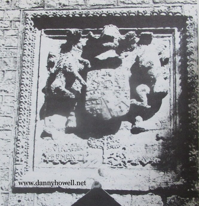
An interesting relic of John and Phillipa, and their son William, found its way from Hill Deverill to Tadley, and later was in possession of Miss Eleanor Ludlow-Bruges at Rodney House, Trowbridge. This was a fine piece of heraldic stained glass, depicting a shield enclosed within a circle, a foot in diameter, upon which were emblazoned, the arms of Ludlow, impaling Bulstrode, described by the College of Arms as:
Argent, a chevron between three martens’ heads erased sable – Ludlow: impaling ‘Sable, a stag’s head cabossed Argent, between the attires Or, a cross of the last, and pierced above the nostrils by an arrow in fess, point to the sinister, also Or, feathered of the second, the nostrils dripped blood proper. (4)
According to the note recorded of this window, the circle surrounding the shield bears the following inscription:
I. Ludlow, son & heir of I Ludlow & phellyp hys wife, dowghter of W bulstrode.
At first glance this would seem to indicate that John & Phillipa had a son and heir also named John: this, however, is not so (see family pedigree at Appendix A) as the name of their heir was William. It is apparent, therefore, that a comma after the words ‘son & heir of I. Ludlow’ has been omitted in transcript. If this is a correct assumption then it is likely that the window provides us with a clue as to the age of the existing manor house, which was probably built by John and Phillipa soon after the former inherited his father’s estates in 1488.
William Ludlow was buried in the Church of the White Friars in London; in his will he required his executors to cause a ‘remembrance’ of him to be made at Hill Deverill Church – or as he also described it, ‘a picture of me’. It is presumed that by these words he meant an effigy to be placed upon the altar tomb, which is still to be seen there with its splendid heraldic carvings, very similar in style to those in the church at Erlestoke. There is no trace of the tomb ever having supported such an effigy and one must assume that his executors either failed in their task or that it was displaced during the rebuilding of the church in 1841.
William’s son, George Ludlow, was appointed High Sheriff of Wiltshire in 1567 and it was within a year or two of this date that Roger de Stanter, whose family had held the manor of Kingston Deverill for some 250 years, sold this to him – together with the manor of Horningsham – and thus commenced a chain of property acquisitions by the Ludlow family over the next two generations which must have been in part motivated in the first instance by the actions of their land-hungry neighbour, Sir John Thynne.
John Thynne was born in 1515, the son of a Shropshire farmer from Church Stretton, three or four miles from Stokesay Castle, the family home, by strange coincidence, of both the Ludlows and the de Vernons. He purchased Longleat, which included sixty acres of land, a water mill and an old priory, from Sir John Horsey in the spring of 1540 for the sum of £53. He left home at an early age and was introduced to the Court of Henry VIII by his uncle, William Thynne, who was Clerk to the Royal Kitchens and said to be held in much favour by the king. John’s qualities immediately caught the eye of Edward Seymour, Earl of Hertford and brother-in-law of the king, and he entered the household. With the increasing age of Henry VIII much of the task of running the country fell into Seymour’s hands, particularly the sale and disposal of the lands and possessions of the dissolved monasteries. Amongst these, as we shall see below, were the manors of Longbridge Deverill and Monkton Deverill which, with the manor of Brixton Deverill held by King’s College, Cambridge, flanked the Ludlow holding of Hill Deverill.
Thynne was arrogant, ruthless and naturally acquisitive: he was also a keen administrator and within a few years he was lord of the manor of some 6,000 acres and he could boast his independence. In 1547 he accompanied his master, now Duke of Somerset and Protector of the Realm, to a Scottish war aimed at bringing about a marriage union between the four year old Mary, Queen of Scots, and the boy King, Edward VI. Thynne so distinguished himself upon the battlefield that he is said to have been knighted by Somerset whilst still bleeding of his wounds.
Somerset was a first class soldier and an honest and sincere man, whose sympathies – at a time of the many changes inevitably brought about by the Reformation of the Church – lay with the common man rather than with the nobility. He therefore made many powerful enemies. On June 1st 1549 (5), whilst not being opposed to the need for enclosures (he appreciated England’s economic dependence on the wool trade and the consequent importance of increasing the sheep population) he issued a proclamation aimed at restricting the robber-baron behaviour of landowners. His authority was ignored both by the gentry and the peasants and there were risings of the latter, both in the West Country and in East Anglia. Somerset was ousted from power and Sir John Thynne, suffering from the reflection of his master’s disgrace, was exiled to his country estate; but not for long. In 1553 he was appointed Comptroller to the young Princess Elizabeth, who succeeded to the throne three years later; within a few years, Sir John Thynne was a member of Parliament for Wiltshire, High Sheriff of the County, and High Captain of the County Levy.
In being granted these appointments he was pursuing a course to be followed both by George Ludlow and his son, Edmund. Since both these influential and neighbouring families had so many ambitions in common, and since the abrasive Thynne moved so quickly to the top of the county tree, it would not be surprising if they held no fondness for each other. An indication of this is perhaps given by the fact that Sir John gave the name Ludlow to one of the two dogs which always closely followed him on his perambulations of his estate. (6) By a strange coincidence both men, George Ludlow and John Thynne, died in the same year, 1580. If Sir John Thynne’s son – also called John – lacked his father’s character and enthusiasm, the same could not be said of George’s son, Edmund, who became member of Parliament for Hindon in 1604. Before then, in 1593, he was successful in enclosing much of the land of the manor of Hill Deverill despite a vigorous protest by his tenants, many of whom were reduced to beggary, and a consequent but unsuccessful Star Chamber enquiry. (7)
It is not surprising that a lot of bad feeling was engendered locally by the acquisition of land in this manner; poaching became commonplace by villagers who went out to snare or kill game on land which they considered to be theirs by right. It is recorded that one year (8) a pitched battle took place on the Longleat estate between eight gamekeepers and a local gang, two of whom were seriously wounded and placed in the stocks on Crockerton Green. Such were the times in which they lived that nobody offered any help to them and in two days both were dead.
In 1606, the third year of the reign of James I, Edmund Ludlow continued with his land acquisition by purchasing Hussey Deverill which in early days had been an integral part of Longbridge Deverill. It is interesting to examine the historical background to its creation as a separate manor.
Longbridge Deverill was granted circa 924 AD by king Athelstan to Wulfhelm, Saxon Archbishop of Canterbury. When Wulfhelm died, some ten years later, the holding of the manor was granted by royal charter to the Abbey of Glastonbury and the manor in their hands enjoyed the disciplines of a Hundred and of being styled a Free Manor. It comprised, with Monkton Deverill, part of the holdings of the Abbey which went to make up the Hundred of South Damerham, the remainder lying in South Wiltshire around the villages of Damerham and Martin. Longbridge Deverill also included the hamlet of Crockerton within its boundaries.
The Abbots held the manors of Longbridge and Monkton until the dissolution of the religious houses by Henry VIII and the execution of Abbot Whiting in 1539 when, along with other possessions of the Abbey it ‘escheated’ to the Crown. The holding of Longbridge then formed part of the dower of Catherine Parr until the death of the king in 1547 when it was purchased of the Court of Augmentation by Sir John Thynne, together with the manor of Monkton Deverill, which he was already sensibly holding of the Abbot at a rental of £39.17.2d. The land in Longbridge, which many years previously the Abbey had granted as an ancient feoffment to the Hussey (Huse) family to perform military service for the Abbot, was not included in the transaction. This land lay in the southern area of the parish, roughly from the Marsh up to Cow Down and eastwards to the boundary of Sutton Veny. The first record of this feoffment is 1168, when Radulphus Huse is shewn as providing this service for a ‘knight’s fee’ but it is very probable that the family were in possession some years before that date. The Entitlement descended from the Husseys to Philip, son of John de la Mere of Nunney Castle, and from thence through several hands until the land was sold in 1605, by Christopher Hinton to Sir Edmund Ludlow. The Ludlows, in turn, at a later date in about 1641, sold it to Sir James Thynne and it again merged in the superior manor of Longbridge Deverill from which it had been so long separated. (See Appendix A.)
It is also of interest to note in passing that in 1391 the Abbot of Glastonbury, with the royal assent of Richard II, (9) annexed the churches of Monkton and Longbridge. The effect of this was to be that on the dissolution of the monasteries, the two churches were sold as part of the estates of the manors concerned, and the Thynnes received the privilege of becoming lay Rectors of the parishes. For this reason the ancient manor house of Longbridge Deverill, which was situated in the walled area to the north of the church, was often used by the family as a residence, particularly so after the great fire at Longleat in 1567, when the Thynnes moved into their house at Corsley. The manor house at Longbridge continued in use by them up to 1600. In a survey of estates in 1639 it is described as ‘a very faire new built house, wherein the said Sir Thomas Thynne sometimes lived, with out-houses, a dove house and water myll adjoining.’ The latter were still in existence in the early 19th century. (10)
Sir Edmund Ludlow married twice; his first wife was Bridget, daughter and sole heiress of Henry Coker of Maypowder in Dorset, by whom he had ten children; she died in September 1587, and is buried at Hill Deverill. Edmund then married Margaret, daughter of Henry Manning of Down in Kent, by whom he had a further four children, and by each marriage confusingly called the eldest son by the forename Henry. Indeed it must be said that the custom which persuaded all branches of the Ludlow family to persist with the use of the forenames Henry and Edmund does nothing to make life easy for present day researchers of the family history.
On 20th April 1625, in the year following Edmund’s death, an Inquisition was taken at Salisbury which showed him ‘seised’ of the manors of Withford, Sherborne, Kennet and Wallop and ‘all of that capital mansion house within the park of Withford alias Tadley Park . . . and all those manors of Hill Deverill, Kingston Deverill . . . and the woodlands called Sowley and Elye in the parishes of Heytsburie and Sutton . . . (and) of the manors of Fifield alias Fiffit and Deverill Hussey co Wilts, and land, meadows and pasture in Longbridge, co Wilts called Burleis Farm.’
Upon succeeding to his father Edmund’s estates, it was not long before Henry Ludlow of Hill Deverill, Bridget’s son, vacated the manor in favour of his son Edmund, and took up residence in Tadley, where he appears to have made no effort to gain popularity. The Hampshire Victoria County History (11) records that ‘he seems to have oppressed the tenants in . . . various ways, pulling down their houses, failing to give them their wages and utterly refusing to pay all rates and taxes. In 1639 he was ordered to redress the grievances of his tenants but he died a month or two afterwards, being succeeded by his son and heir, Edmund, who conveyed the manor to Joseph Blagrave in 1641.’
The Ludlow coat of arms over the door at 86 Monkton Deverill.
As we have already seen, when Henry vacated Hill Deverill he took with him to Tadley a heraldic stained glass window, emblazoned with the arms of the Ludlows. It is very probable that Edmund replaced this window externally with the carved stone replica of the Ludlow coat of arms which today may be seen on the village house at Monkton Deverill and which was later to be occupied by his Coker heirs. In the words of Colt Hoare, he added to the device ‘three dogs running to a tree for shelter, which might allude to the hard usage which he met with from his family . . . the three dogs may be figured his three brothers, the authors of the persecution.’ Whatever form this persecution may have taken, there can be little doubt that it had financial origins and the family was falling into increasingly straitended circumstances, a conjecture perhaps strengthened by the fact that Edmund disposed of both Hussey Deverill and the Tadley property in the same year, 1641.
After the death of his wife Bridget, Edmund’s grandfather, also named Edmund as will be recalled, went to live at Maiden Bradley in a house which he leased from the Duke of Somerset for a period of three lives. It was here that his son, Henry, by his second wife Margaret, was born. Henry was a man of strong political convictions; he represented Wiltshire in the Long Parliament, and in 1642 was rebuked by the Speaker of the House for expressing the view that the king was unworthy to be king of England. In view of the strong political opinions of his father, it is not surprising to find that his son, later Lieutenant-General Edmund Ludlow, followed the political convictions of his parents and joined the Parliamentary forces at the outbreak of the Civil War. After the battle of Edgehill, in October 1642, he became a captain of a troop of horse in Sir Edward Hungerford’s regiment. He was not present for the main part of the siege of Wardour Castle, when Lady Arundell, with a party of some twenty-five persons, many of whom were women, gallantly defended it against the rebels for a period of several days, until she was compelled to surrender by the explosion of the second of two mines laid by Hungerford under the building.
Parliament, having resolved that Wardour Castle should be maintained as a garrison, appointed Ludlow as its governor; but after the Royalist victory at Roundway Down outside Devizes, his position was rendered precarious. The nearest garrisons from which he might expect help were hardpressed Gloucester, Portsmouth and, to a lesser degree, Poole. Despite the advice of his father and friends, and despite the fact that the position was of little military value, he defended the castle against Royalist attack for four months, until March 1644, when according to the Royalist newspaper Mercurius Aulicus:
Master Ludlow left off preaching within four or five days, for when he saw the mine deprive him of his fortifications he delivered up himself and all the garrison (of 75 persons) without so much as a promise of quarter, with all the cannon, arms, ammunition, baggage and the lord Arundell’s plate, which it seems had not yet found the way home . . .
After a short imprisonment he was released and exchanged, and in July he was appointed Colonel of a Regiment of Horse in the pay of the Wiltshire Committee.
In the summer of 1647, General Ludlow took the part of the Army in their quarrel with Parliament. Although in his Memoirs he states he had a preference for the monarchy, and was alienated from Cromwell by these views, in 1648 he was nevertheless appointed one of the judges at the trial of King Charles I. Moreover, on 30th January 1649, when the monarch was beheaded as a public enemy, to the revulsion of the great majority of Englishmen, the name of Edmund Ludlow appeared as fortieth on the list of those signing the death warrant. Upon the Restoration of the Monarchy, Ludlow was branded a regicide and, having already fled the country, he died at Vevey, in Switzerland, in 1692.
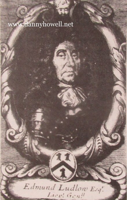
Lieutenant General Edmund Ludlow (1617 – 1692) of Maiden Bradley, grandson of Edmund Ludlow of Hill Deverill. He was one of the signatories of the death warrant of Charles I.
The part which the Deverills played in the Civil War is uncertain. Brocklebank, reflecting on the remains of the old British Village which today are to be found on the opposite side of the road to Hill Deverill manor house, considers (12) it may have been a medieval village ‘destroyed in the Parliamentary Wars by being burnt, together with the Rectory and Tithe Barn.’ The well known Wiltshire historian Rev. J.U. Powell, writes (13) ‘it is said that the mounds and ditches facing the church are the remains of houses in the village which were battered down by the Royalist cannon mounted upon Burnbake, between the Manor House and the Shaftesbury Road.’ There is, however, no documentary proof of any such incident having taken place and it would not be unreasonable to expect that some record would have been made of a major action of this nature. On the other hand, when Greentiles, the bungalow standing on the left of the approach road to the Manor House, was being built, a substantial chalk and stone foundation was uncovered, together with three stout timber supports. These latter appeared to have been burnt and were conjectured to have come from a Tithe Barn which originally stood upon that place. Additionally, Mr. & Mrs. Wood, the present occupants, state that they have occasionally discovered old musket balls when working in the garden of their bungalow.
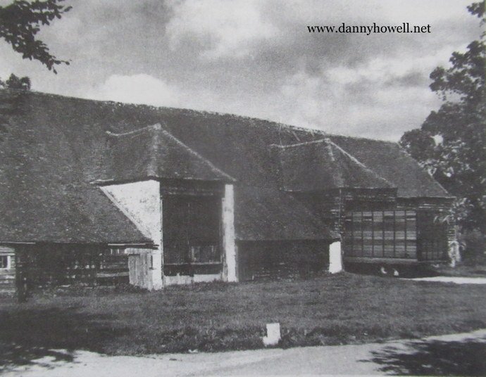
The tithe barn at Hill Deverill, built circa 1550.
It is said to have housed a troop of Roundhead
cavalry during the Civil War of 1642-1646.
There is also a tradition at Hill Deverill that Cromwell stabled his horses in the old Manor House barn during the Civil War. Again there is no evidence that Cromwell ever visited the village, although it is known that he went to Devizes. There was, however, a cavalry patrol encounter on the Heath, above Warminster Common, adjoining the Deverill Road. (14) It is not unlikely, therefore, that some of Hungerford’s regiment, which took part in the sieges of Wardour Castle and Woodhouse Castle at Horningsham, stabled and watered their horses in the Manor House barn when operating in the area. Ludlow’s Memoirs record:
Out of Wiltshire they write that Sir Edward Hungerford is returned with Colonel Stroud to Mear, whither they have brought with them 700 horse and foot, and also that they were there joyfully entertained, and had free quarters given to them; and that during their abode at Mear their soldiers seized upon Master Arundell’s catell and killed almost all his goats on Horningsham Common, and they also got into the parke at Longleat and killed some of Sir James Thinne’s fallow deer . . .
Behaviour of this nature did not endear the troops of either side to the local population, and in the years 1643 and 1644 (15) there were some popular disturbances in the Selwood area, arising from the burden which was being imposed upon the country people by the military presence.
The loyalties of the landlords were varied. Sir James Thynne, a soldier who had distinguished himself in continental wars, was probably a Royalist: he took no part in the uprising but concerned himself with the administration of his estates and the safeguarding of his livestock, although apparently even these suffered. There was no doubt about the political sympathies of the Ludlows at Maiden Bradley: they were fervently Roundhead. Kingston Deverill, with its close association with the Arundells of Woodhouse Castle and Horningsham, was probably Royalist in its outlook. Edmund Ludlow of Hill Deverill was an old man and may be expected to have maintained a reasonably neutral attitude, probably concealing Parliamentary sympathies. He died in 1645 about four years before the king’s death upon the scaffold.
Edmund, who was the son of Henry Ludlow of Tadley, was succeeded by his daughter and heiress, Elizabeth, (16) wife of Sir Henry Coker of Maypowder. If an illustration were required as to how cruelly families were divided by their loyalties in those momentous days, Sir Henry Coker and his wife are prime examples; for he was an ardent Royalist who fought for the King at the battle of Worcester and a rare portrait of him held by the Powell family (17) displayed the following inscription:
The Honble Sir Henry Coker of the County of Wilts, Knight, High Sheriffe, Ano 63, Coll: of Horse and Foot to King Charles the First; Coll: to the King of Spayne, and Coll: to his Ma: that now is for the servis of Worcester, now Gent: of the Privy Chamber, aetat 48. 1669.
There is some uncertainty about the true date of his death but he is thought to have predeceased his wife in 1693 when 72 years of age. Elizabeth bore him several children but her son and heir, also Henry Coker, died without issue in 1736 at the age of eighty; he was therefore succeeded by his nephew William Coker, who ‘burthened with a debt contracted by his ancestors and increased by a long and expensive law suit’, first sold Hill Deverill in 1737, and later the Somerset estates of the Cokers, to the family of the Duke of Marlborough. It must have been whilst these events were taking place that the Cokers moved to the village house at Monkton Deverill, which to this day bears the Ludlow arms, albeit so badly weathered as to be almost illegible.
In an age when the gap between the aristocracy and the working people was considerable but class consciousness was minimal. Henry Coker was not popular with the country people amongst whom he lived; but many of the tales which were generated about him derived probably from the fact that he lived alone to a considerable age. More than 150 years after his death it was still being related that he was a robber and that ‘many went into the house that never came out’; (18) there was also said to be blood marks on one bedroom floor and the farm was described as a ‘den of thieves’, associated with smugglers. It is very possible that smuggling was prevalent in the district and that some of these stories were circulated to frighten villagers off the roads at night time. Powell records that, at Longbridge Deverill, local people were afraid to go up Church Lane in the dark lest ‘woolpacks should roll down from the thicket upon them’: and kegs of brandy were said to have rolled out of the hedgerows. Whatever the reasons, and these probably included the straitened circumstances in which the family found itself, the name of old ‘Henry Coker’ provided a lively contribution to the folklore of the Deverills up to the turn of the century when, for example, some farm labourers saw his ghost ‘sitting on the dreshol (threshold) of the barn, so that they had to go in another way.’
It is also said to have been related of him that he kept a cannon at the round window over the porch of the manor house to fire at would-be intruders and that after his death he was to be seen heading a ghostly hunt across the Pertwood downs. Trevelyan explains the growth of this sort of story by pointing out that this was ‘the last era in our island history when the village was the normal unit of society. Under the first two Georges most men and women, including many not engaged in any form of agriculture, were in the full sense of the word “villagers”. They were interested, not in the political, athletic and scandalous chronicle of the world at large, of which they heard seldom and little from the newsheets of the day, nor in the life of town, factory or trade union, but simply in the daily human drama of their own village, set amid its surrounding fields and woods, with its traditions, its ghost stories, its neighbourliness, its feuds, and its shrewd, ignorant, rustic comment on the mysterious world beyond.’ (19)
Notes
1. In 1437 William was also made ‘gauger’ of the City of London for life ‘for good service’; he was granted the manor of Ludgershall in 1440. In later years he was appointed Chief Forester of the Isle of Wight and keeper of Carisbrook Castle: hence the Ringwood interest in the family.
2. Wiltshire Archaeological Magazine [W.A.M.], vol.15, p.332.
3. W.A.M., vol. 28, p.246. A carucate equalled 100 acres.
4. Bulstrode, Wiltshire Notes and Queries, vol.7.
5. Chapman, H., The Last Tudor King, Cape, 1958.
6. Burnett, D., Longleat, Collins, 1978.
7. Star Chamber Documents 5/A/11/8, Public Records Office.
8. Longleat Records, vol.2, f.221.
9. Hoare, Sir Richard Colt, The History of Ancient Wiltshire (Hundred Of Heytesbury), 1812.
10. Ibid.
11. The Victoria County History of Hampshire, vol.4, p.220.
12. W.A.M., vol.42, p.252.
13. W.A.M., vol.28.
14. Ibid.
15. The Victoria County History Of Wiltshire, vol.5.
16. Hutchin’s Dorset, Wiltshire Record Office.
17. Powell, Rev. V.V., W.A.M., vol.28, p.249.
18. Powell, Rev. V.V., Folklore, vol.12, March 1901, Folklore Society, c/o University College, Gower Street, London, W.C.1.
19. Trevelyan, G.M., Illustrated History of England, Longman, 1964.
Appendix A
The Ludlows Of Hill Deverill
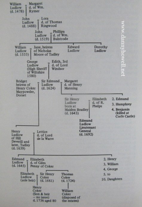
Appendix B
Table to Illustrate the Succession of Owners of Hussey Deverill
1168 Radulphus Huse is shown as providing military service to the Abbot of Glastonbury for a ‘knight’s fee’. Possession might have been earlier.
1390 The entitlement descended from the Hussey family to Philip, son of John de la Mere of Nunney Castle.
1415 Elias de la Mere died and his sister and heir married William Paulet, second son of Sir John Paulet, ancestor of the Marquis of Winchester.
1572 William Paulet, Marquis of Winchester, sold to William Mullens.
1575 William Mullens sold to William Burley.
1588 William Burley sold to Richard Hinton.
1604 Christopher Hinton sold to Sir Edmund Ludlow of Hill Deverill Manor.
1641 Sir Edmund Ludlow, grandson of the Ludlow mentioned above, sold to Sir James Thynne and thus completed the circle. It is interesting to note that the Civil War was to break out in the following year, and Sir Edmund was to die in London within four years, whilst the troubles were still continuing.
From The West Wiltshire District Guide 1978:
The villages of Kingston Deverill, Monkton Deverill and Brixton Deverill are situated in the south-west corner of the district astride the Longbridge Deverill – Mere road. These unspoilt communities lie in the scenic rural valley which reaches like a finger into the Downs around Mere and which also marks the source of the River Wylye. The Downs rise on either side to a height approaching 1,000 feet. The area boasts an association with King Alfred as well as an abundance of pre-historic features. Farming continues to be the main activity.