
Friday 23rd March 2018
Posted by James Saunders on youtube, 23rd March 2018.
Two Iron Age Hillforts in Wiltshire, and attempts to discover why one was abandoned in favour of the other.
Friday 23rd March 2018
Posted by James Saunders on youtube, 23rd March 2018.
Two Iron Age Hillforts in Wiltshire, and attempts to discover why one was abandoned in favour of the other.
Friday 1st April 2016:
Battlesbury Camp, Warminster, according to the Heritage Daily website, is No.6 in a list of the ten must-see Iron Age hill forts in Britain. “There are around 3,300 structures that can be classed as hill forts or similar ‘defended enclosures’ within Britain, all worthy of considering.” High praise indeed then that Battlesbury should be among the ten most impressive examples, but no surprise to those of us in Warminster who take a great interest in such things.
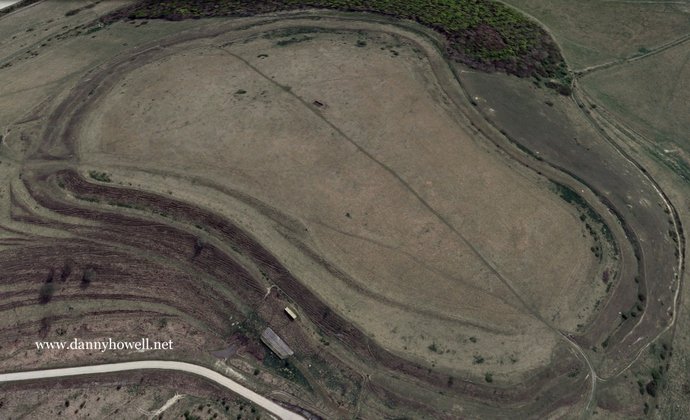
Battlesbury Camp is the site of an Iron Age bivallate hill fort on Battlesbury Hill in Wiltshire in South West England. Excavations and surveys at the site have uncovered various finds and archaeological data.
Battlesbury occupies the summit of an irregular point of down, with its defences following the natural contours of the hill, and being by nature of the site almost inaccessible on the west and north-east sides. It has triple ditches and ramparts for the most part, with double on the south-east side. The site encloses 23.5 acres in all. There are entrances at the north-west and north-east corners.
Pits found within the fortifications contained late Iron Age pottery, the hub of a chariot wheel, an iron carpenter’s saw, a latch-lifter for a hut door, querns, whetstones, sling stones, and animal bones. These all indicate a permanent occupation and date from the 1st century BC. Unfortunately it is suspected that the hill’s inhabitants came to a violent end, due to the many graves containing men, women and children outside of the north-west entrance. It can only be guessed at whether Roman legions put people to the sword, or if this was the result of intertribal warfare sometime before the Roman conquest.
To see the list of the ten most impressive Iron Age hill forts in Britain, click on:
http://www.heritagedaily.com/2014/07/top-ten-iron-age-hill-forts-in-britain/100759
Battlesbury, Warminster. A fine example of an Iron Age hill fort.
Some notes compiled by Danny Howell in 1990:
The Iron Age hill fort of Battlesbury is strongly defended by double ramparts and a ditch on its south west side, with triple ramparts on the less steep side to the west. These ramparts follow the kidney-shaped contours of the hill and encompass an area of nearly 25 acres. The upper rampart was topped by a wooden defensive wall, long since gone.
The settlement was entered by gates at the north west and east. Both of these have outworks, indicating structures to facilitate controlled entry and exit. The east entrance probably featured a barbican or overhead wooden fortification for the guarding of the passageway into the camp.
The eastern slopes of Battlesbury feature strip-lynchets: narrow strips of level land breaking up the hillside slope. These terraces are the result of soil accumulation from the ploughing of ancient fields. Iron Age in origin, these lynchets were also farmed in Saxon times, and are still cropped today.
A round mound between the ramparts on the brow of the southerly slope is marked on some maps as a barrow or burial mound but excavation in the early I800s by Sir Richard Colt Hoare revealed no burial. It could be the remains of a small castle motte.
Mrs. M.E. Cunnington found 11 storage pits within the fortifications in 1922. These contained late Iron Age pottery, the hub of a chariot wheel, an iron carpenter’s saw and a latch-lifter for a hut door. These finds, which are now at Devizes Museum, suggest that the hill was used as a permanently occupied site.
In May 1922 a trench was dug across the camp so a pipe could be laid from the west gate supplying water to a concrete tank situated on the east side of the hill. Victor Manley watched as the workmen uncovered Iron Age features. In his Regional Survey Of The Warminster District (several volumes, unpublished) he noted “I was able to measure line after line of shallow but straight depressions running across the hill top roughly in a north-south direction, and this in spite of centuries of ploughing over them. There seems to have been lines of streets, of houses or huts made of wattle and daub. Judging that the depressions indicate the rows of houses and the black earth spaces between where the waste was thrown, there would have been about 26 streets for the settlement.â€
Excavation of a pit just outside the north west entrance yielded a number of burials, including the skeletons of men, women and children. This seems to indicate that a massacre took place there but whether this was due to inter-tribal warfare before the Roman Conquest or was the bloody result of a violent confrontation with the advancing Roman legions is not known.
The name “Battlesbury†is now associated with local folklore concerning a massacre on the hill, although the first part of the name “Battle†could be derived from “Pattel†– a personal name of someone long since forgotten. The second element of the name “bury†comes from “Burh,†meaning “an ancient camp.â€