Kingdown School – “Shape Warminster’s Future” initiative from Warminster Town Council

Wednesday 11th March 2026

Shape Warminster’s Future” initiative from Warminster Town Council.

Dear Parents/Carers,

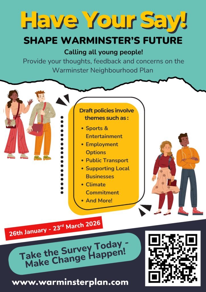
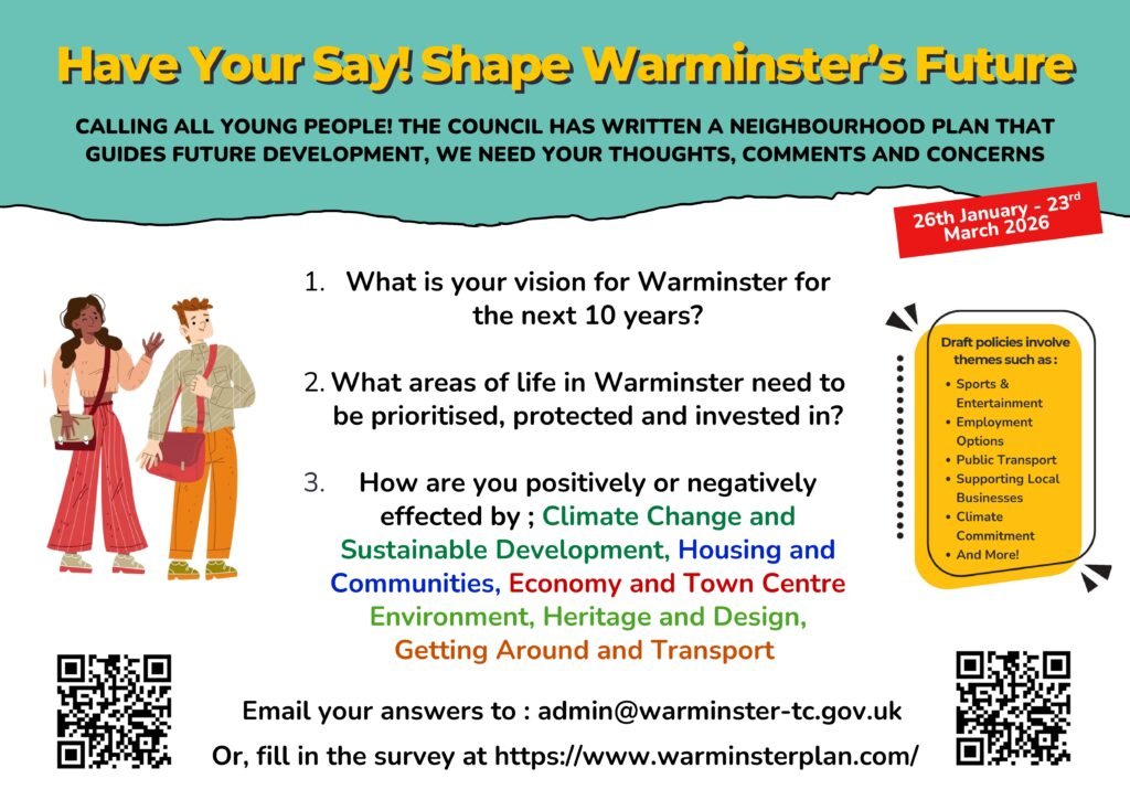
We would like to let you know about an exciting opportunity for students to have their voices heard in the â€œShape Warminster’s Future” initiative from Warminster Town Council.

Students are invited to take part in a short survey by scanning the QR code provided. The survey gives young people the chance to share their views on what is happening in Warminster and what they would like to see in the future.

The survey covers a range of important topics, including:

  • Sports and entertainment opportunities
  • Employment options for young people
  • Public transport
  • Supporting local businesses
  • Climate commitments
  • And much more

This is a great opportunity for students to contribute their ideas and help influence decisions that affect their community.

Please encourage your child to take a few minutes to scan the QR code and complete the survey so that their voice can be included.

Thank you for your support.

Kind regards,

Kingdown School Logo

Kingdown School

Woodcock Road
Warminster
Wiltshire
BA12 9DR

t: 01985 215551

e: admin@kingdown.wilts.sch.uk

w: https://www.kingdown.wilts.sch.uk/

Locally Valued Heritage Assets (LVHA) ~ Sandy Hollow, Smallbrook Road

From Appendix 7.8 – Warminster’s Heritage Topic Paper. Additional information to support the Warminster Neighbourhood Plan. Produced in 2024.

Locally Valued Heritage Assets (LVHA)

Map Ref. No.

Database Ref.

Asset Name:

Description:

How asset met Historic England critera –
Rarity (R)
Architectural or Artistic Interest (AA)
Group Value (GV)
Archaeological Interest (AI)
Historic Interest / Association (HI/A)

Deceased Persons (Surnames Beginning With C), Interred By F. Curtis & Son, At St. John’s Churchyard, Warminster

This list comprises the names of deceased persons (surnames beginning with C), interred by F. Curtis & Son, funeral directors, at St. John’s Churchyard, Warminster.

The list is organised alphabetically by surname, followed by the year of interment, followed by grave plot number.

Leslie Charlesworth, 1995. Plot 110. Ashes.

Winifred Elizabeth Churchward, 1992. Plot 1158.

Joyce Clayton (written Jocye Clayton), 1995. Plot 109. Ashes.

George Edward Clifford, 1989. Plot 503.

Dennis Collins, 1992. Plot 88. Ashes.
Wallace Collins, 1985. Plot 435.
William Charles Collins, 1995. Ashes.

Doris Mabel Cooper, 1991. Plot 830a.
George William Cooper, 1997. Plot 1606.
Robert William Cooper, 1993. Plot 34. Ashes.

Olive Louise Corden, 1987. Plot 355.
Winifred Jane Corden, 1984. Plot 1142.

Lilian Coventry, 1986. Plot 466.

William Valentine Culverhouse, 1985. Plot 441.

Sidney Andrew Cunningham, 1984. Plot 334.

Alice Curtis, 1986. Plot 278.
Dorothy Curtis, 1996. Plot 1269.
Edward Frank Curtis, 1988. Plot 297.

The Location Of Flower’s Field Barn, Knook

Flower’s Field Barn, Knook.

Postcode: BA12 0JA.

Condition: Former agicultural building, now residential.

Ten figure OS Grid Reference: ST 95188 43232

Six figure OS Grid Reference: ST951432

what3words example: twins. headline. incursion

In the parish of Knook. Once agricultural, now in residential use. Accessed via narrow road north of the Heytesbury to Chitterne road, just before that road starts to climb Ansty Hill.

The Location Of Willis’s Field Barn, Knook

Willis’s Field Barn, Knook.

Postcode: BA12 0JA.

Condition: Was an agricultural barn. Since converted to residential use.

Ten figure OS Grid Reference: ST 94712 43572

Six Figure OS Grid Reference: ST947435

what3words example: wriggle. childcare. engine

In the parish of Knook. Now a residential property called Knook Down House. Reached from a narrow road/track (bridleway) off the Heytesbury to Chitterne road. The military Southern Range Road is now situated to the north of this property.

The Location Of Bevin’s Barn, Heytesbury

Bevin’s Barn, Heytesbury.

Condition: Barn.

Ten figure OS Grid Reference: ST 93869 43203

Six figure OS Grid Reference: ST938432

what3words example: deprives. clogging. asks

This barn is north of Knook Camp, immediately east of Heytesbury Plantation, and close to the military Southern Range Road. The barn was formerly in agricultural use but is now in military use.

The Location Of Nockatt Coppice Car Park, Horningsham

Nockatt Coppice Car Park, on the Longleat Estate.

Condition: Car park.

OS Grid Reference: ST 82761 42284

Six figure OS Grid Reference: ST827422

what3words example: passage.trickling.bolt

In the parish of Horningsham.

This car park, owned by the Longleat Estate, is on the east side of the road that connects the A362 (Warminster-Frome) road with Horningsham. It is adjacent (outside the fence of) the Centre Parcs holiday village. The car park is situated in the north-west corner of Nockatt Coppice. The car park is often used by people who like to walk from here along the path to Prospect Hill (Heaven’s Gate).

The Location Of Hounds Mead, Boreham (Golden Meadow)

Hounds Mead, formerly in the parish of Boreham, now in the parish of Warminster.

Condition: Pasture field with pond.

Ten figure OS Grid Reference: ST 89296 44034

Six figure OS Grid Reference: ST892440.

what3words example: meatballs.with.cushy

Bounded on the north by the River Wylye, bounded on the west by the gardens of properties on the Bishopstrow Road, bounded on the east by Sweetlands, and bounded on the south by the road which connects Boreham with Bishopstrow.

Currently [2026] known as Golden Meadow, a private nature reserve/private recreation area.

The Location Of Beds Feet, Warminster

Beds Feet, in the parish of Warminster, Wiltshire.

Condition: grassed area.

Ten figure OS Grid Reference: ST87113 45025/

Six figure OS Grid Reference: ST871450.

what3words example: snap.briskly.wreck

Beds Feet is bounded on the west by Sambourne Road, on the north by Primrose Lane (Shittingalleylane) and on the south by Sambourne Gardens.

Carrion Close, Warminster

Danny Howell writes:

Carrion Close was the name of a paddock in Warminster. It lay north of Portway House and was used in the 18th Century for the Warminster October Sheep Fairs. The Woodmead Old People’s Home was built on the site in 1961. It is now occupied by the Crescent Place apartments.